Thursday, May 9, 2013


Image of the Black Rock Playa at dusk with the mountain range for which it is named in the background.


The vast open space offered by the playa has been thousands of years in the making.  What we see today is an entirely different landscape that existed over a million years ago.  This land was once underneath part of the ocean, slowly forming lakes when the climate warmed and the moisture levels and tectonic shifting were instrumental in changing the shape of the terrain.  Located where there were high levels of volcanic activity, the land shifted and moved, forming mountains that we now see the remains of as the Sierra Nevada mountain range.  At the deepest, this ancient lake was close to 500' deep, as evidenced by the wave built terraces that can be seen around the playas edge. 

Remnant lakeshore terraces on  slopes of ridgeline about 11 miles north of Gerlach along County Road 34.  Playa is just right, off picture, view south, 12/12/99.  M Bilbo photo.
Wave cut terraces surround the playa, which is to the right of the mountain in the background. 
M Bilbo photo.


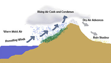
 The lake area was located in what is now Nevada, which are formations called horst and grabens.  Horst being the uplifted part of the land and the grabens being the lower part of the land.  The playa was formed in a graben, which is why it is surrounded by the small mountain ranges all around it.  Over time, the tectonic processes slowed down, the mountain ranges were forming and becoming stable to the lakes west.  Moisture slowly being evaporated and blocked by the mountains, drying up the lake over thousands of years.   The soils began to form dessication polygons on top of the layers of silt, clay and minerals.


Black Rock Desert Playa with large desiccation polygons; view northeast, Black Rock Range on left, 20 Miles Distant, 8/17/95.  Delores Cates photo.
Dessication polygons form when moisture is non-existent for long periods of time.  Photo Delores Cates.


Landscape of Black Rock Desert 1,000 years from now

In 1,000 years from now, the Black Rock Desert will become an increasingly extreme climate, which is evident from global temperature fluctuations due to processes such as changing wind patterns movement of the continental plates.  Temperatures increasing in the Southwest part of North America will cause extreme draught conditions in places like California, melting the snowpack in the Sierra Nevada Mountains.  This loss of moisture in the mountainous areas will cause more wildfires, which will alter the land and cause different types of erosion to happen.  Increased use of the land by humans for recreation in the past will have taken its toll on the playa, stirring up the dust so that the winds form dunes made up of this lakebed material. 


Landscape of Black Rock Desert 10,000 years from now

Black Rock Desert 10,000 years from now will start to change. The mounds created from the winds and loose sediment would get larger, covering the playas surface and allowing the growth of fauna. The creation and movement of these playa mounds would attract migrating birds because of the food supply the ancient crustaceans in the soil and the vegetation would provide.

 Coyote Spring Mound, view north, 9/79.  Delores Cates photo. 
This photo illustrates the type of  mounds that are becoming more abundant over the playas surface.
Delores Cates photo.

 Landscape of Black Rock Desert 1,000,000 years from now

The mounds and increasing moisture due to erosion in the Sierras will increase the vegetation around the playa and spread slowly.  The addition of plant life back into the area will have a cooling effect, and the winds from the west over the ocean will also bring more precipitation to allow for more plant life to grow.  More moisture will activate the dormant Branchiopods, which will feed on the newly formed plant life.  

Conclusion
The desert landscape of the Great Basin area in North America wasn't always a desert and may not always be one.  The changing processes of the earth have proven that the surface we see now may not exist exactly like it has over the last 100 or 1000 years.  Movement of landforms by erosion and weathering can cause dramatic shifts and climate will continue to affect the rate at which these processes happen.

Sources 

http://www.ipcc-wg2.gov/publications/SAR/SAR_Chapter%203.pdf

http://www.dri.edu/component/content/article/180-dees-extended-research/1597-dynamics-of-the-black-rock-playa-relationships-between-use-physical-processes-and-biological-environments


Thursday, April 18, 2013

The climate of the Black Rock Desert is a BWk, a cold midlatitude desert, according to the Koppen Climate Classification System.  This system separates five different climate types by average precipitation and temperature.  The climate of the BWk is characterized by arid climate, high temperatures during the days, colder temperatures at night due to cloud cover being very minimal, and are usually located in a rainshadow.


 This graph shows the mean monthly temperatures and precipitation levels for a city called Lovelock, NV.  This is located about 100 miles southeast of Black Rock Desert, but has similar climate averages throughout the year.  Graph credit physicalgeography.net.


The Black Rock Desert is located in a rain shadow that is caused by the Sierra Nevada mountain range.  The peaks of the Sierra Nevada mountain range can reach as high as 10,000 feet above sea level, effectively cutting off the source of moisture coming from the western side of the mountains.  A rain shadow is the dry area on the lee side of a mountain range, the precipitation causing weather is being blocked by the mountains and makes a dry shadow on the other side of the mountainous area.  The precipitation is released at the top of the mountain, the air advancing over into the valley area and as it descends downward, it then gets warmer and drier.


http://en.wikipedia.org/wiki/Rain_shadowThis illustration gives an example of a rain shadow.  The location of the Sierra Nevada Mountains are the cause of the Black Rock Desert being in a rain shadow.

Precipitation on the playa is less than 10 inches yearly, occurring mostly as snow during the winter months.  This light precipitation helps to keep the silt at the flat bottom of the playa compacted.  When this silt is disturbed by wind or human activity, there are more occurrences of dunes on the playa.  There is research currently being conducted about how much of these dunes are being caused by humans and how much of them occur naturally. This was partly brought to light after seeing the presence of the dunes increase after the beginning of the Burning Man Festival at the Black Rock Desert in the late 1990s.

 
This photo shows the dunes that have formed on the surface of the playa due to winds and loose silt.
 photo credit
July/August issue of Nevada Magazine


 This image is copyrighted by the owner
In this photo there is a dust storm in action, forming from the dry, warm air coming down the mountains on the other side of the playa.  
Photo credit http://www.fredmiranda.com/forum/topic/1040905

Sources
http://en.wikipedia.org/wiki/Desert
 http://www.britannica.com/EBchecked/topic/1555783/mid-latitude-steppe-and-desert-climate
 http://www.physicalgeography.net/fundamentals/7v.html
 http://en.wikipedia.org/wiki/Desert_climate#Hot_desert_climates

Tuesday, March 12, 2013

Geothermal Activity and Fly Geyser


Geothermal Activity and Fly Geyser
In the Black Rock Desert, there is a network of fault lines that contribute to the geothermal activity seen on the surface and edge of the playa.  The fault lines occur around the edge of the basin, near the bottom of the mountain ranges, like that of Granite Range, that surround the playa and are the location of the geyser and hot spring activity.  The particular type of fault seen here, known as a thrust fault, is a result of the compression of the upthrown block on top of the downthrown block of earth at a low angle.  This is the reason we can see mountain ridges around a fairly flat surface such as the Black Rock Desert playa.  
 

On this map, Fly Geyser, Double Hot Springs and Trego Hot springs are located at the edge of Black Rock Playa, which is the part of the desert basin that was once the bottom of the lake bed of the ancient Lake Lohontan.
Map credit www.americansouthwest.net


Located on the western edge of the Black Rock Desert is Fly Geyser.  This is an example of the geothermal resources that Black Rock Desert has available.  The man made geyser sits on private property and was made by accident in 1916. A well was being drilled in hopes to make use of the water for irrigating the dry land.  As the well was being drilled, a, geothermal source of water was penetrated.  The water that came up was nearly 200 degrees, unusable for farming.  A second attempt to drill a well also failed and abandoned at the site in the 1960's.  The water ejected from the geyser is rich in minerals, such as calcium carbonate, and has formed a cone shape around the original well pipe.  Over time, these deposits have progressed from small cone shaped deposits around the geyser opening, to bulbous and vividly colored formations,  the water in constant flow from the geyser.  The thermophilic algae that grows on the mineral deposits thrives on the mineral deposits and create the unusual red and green colors that develop over the surface. 

The geyser, which has been nicknamed The Three Buddhas because of the shape the deposits have formed, is about 5 feet in height and still growing.  Photo credit www.allovermap.com

In this photo, the geyser flows through the mineral deposit formed cones, which are made the bright colors by heat resistant microorganisms called thermophilic algae that inhabit the surface.  Photo credit explore-mag.com


Sources
ftp://ftp.nbmg.unr.edu/pub/.../11.../Schaefer_OFR-81-918.pdf
atlasobscura.com/places/fly-ranch-geyser
http://en.wikipedia.org/wiki/Fly_Geyser